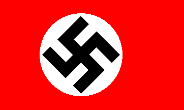
 |
 |
 |
1941-APR-06 |
 |
 |
 |
1941-APR-06 |
| Greater German Empire : GERMANY [Nazi Germany Third Reich] | Imperial Districts of OSTMARK [East March Territory] | Imperial District of LOWER DANUBE | |
 |
 |  |
 |
| (Berlin a + Berchtesgaden r) | (Vienna) | (Krems) |
 |
SOUTH MORAVIA District |

|
| Flag or logo since 1938-10-01* | (Emblem or Symbol of LOWER DANUBE) |
 Reichpresident Fuhrer Adolf Hitler (ruler of GERMANY since 1934-08-02) |
| Capitals & administrative places*: | Znaim (Znaim) |
|
| Official & national languages: |
|
Other Independent or Semi-Independent Polities within the 2024's internationally recognized Country boundaries: |
| BOHEMIA AND MORAVIA | German Imperial Protectorate of BOHEMIA AND MORAVIA (Prague a + Lany r) |
Other Territories or Entities within the 2024's internationally recognized Country boundaries: |
| BAVARIAN FOREST | BAVARIAN FOREST District (Klattau) |
| BOHEMIA | Land of BOHEMA (Prague) |
| EGER | Municipal District of EGER [German Enclave in Bohemia-Moravia] (Eger) |
| FELDSBERG | Liechtenstein Property of FELDSBERG [in Breclav District] (Feldsberg) |
| MORAVIA | Land of MORAVIA (Bruenn) |
| SOUTH BOHEMIA | SOUTH BOHEMIA District (Krummau on the Moldau) |
| SUDETES | Imperial District of SUDETENLAND (Reichenberg) |
| TRANS-OLSA | TRANS-OLZA Territory (Czech Teschen) |
| |
|
|
ethnia.org © J.-M. Merklin |
 |

|