1912-MAR-25 |
1912-MAR-25 |
| UNITED KINGDOM SOUTH AFRICA | British Dominion of the UNION OF SOUTH AFRICA | ORANGE FREE STATE Province | EASTERN ORANGE FREE STATE District | |

| |  |  |
|
| (London a + Westminster lr + Edinburgh s + Windsor r) - (Pretoria ae + Cape Town l) - | (Pretoria ae + Cape Town l) | (Bloemfontein) | (Harrismith) |
 |
WITSIESHOEK District |
|
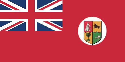
| Flag or logo since 1912-03-25* | Emblem or Symbol* |
|
| Capitals & administrative places*: | Witsieshoek (Witsieshoek) |
|
| Official & national languages: | English (en) . Dutch (nl) . |
|
Other Independent or Semi-Independent Polities within the 2024's internationally recognized Country boundaries: |
| SOUTH AFRICA | British Dominion of the UNION OF SOUTH AFRICA (Pretoria ae + Cape Town l) |
Other Territories or Entities within the 2024's internationally recognized Country boundaries: |

