ethnia.org   
 

1916-AUG-01


ASIR (Sabyah) Rebellion Idrisid Emirate of ASIR : Imam and Emir Sidi Muhammad II bin Ali al-Idrisi al-Hasani
UPPER ASIR (Abha) Rebellion Independent Sheikhdom of UPPER ASIR : Sheikh Al-Hasan Bin Ayad

Other Entities with similar names

Idrisid Emirate of ASIR
(Sabyah)

Idrisid Emirate of ASIR

Flag or logo since 1909-01-02*
Imarat al-Adarissah bi-´ASSIR : إمارة الأدارسة بعسير (ar) RebellionDe facto Independent
Emblem or Symbol*

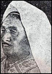
Imam and Emir Sidi Muhammad II bin Ali al-Idrisi al-Hasani
(ruler of ASIR since 1914-01-01)


Capitals & administrative places*: Sabyah
(Sabyah)
Official & national languages: Arabic (ar) .

Mainland:


LOWER ASIR Emirate of LOWER ASIR  (Sabyah)

13 Divisions:

ABU ARISH ABU ARISH Region  (Abu Arish)Local: ABU ARISH  (Abu Arish)
AHAD AL MASARIHAH AHAD AL MASARIHAH Region  (Ahad Al-Masarihah)Local: AHAD AL-MASARIHAH  (Ahad Al-Masarihah)
ARIDAH ARIDAH Region  (Al-Aridah)Local: AL-ARIDAH  (Al-Aridah)
AYDABI AYDABI Region  (Al-Aydabi)Local: AL-AYDABI  (Al-Aydabi)
BAYSH BAYSH Region  (Baysh)Local: BAYSH  (Baysh)
DAIR DAIR Region  (Ad-Dair)Local: AD-DAIR  (Ad-Dair)
DAMAD DAMAD Region  (Damad)Local: DAMAD  (Damad)
DARB DARB Region  (Ad-Darb)Local: AD-DARB  (Ad-Darb)
HARTH HARTH Region  (Al Harth)Local: AL-HARTH  (Al-Harth)
JIZZAN JIZZAN Region  (Jizzan)Local: JAZAN  (Jazan)
RAYTH RAYTH Region  (Ar-Rayth)Local: AR-RAYTH  (Ar-Rayth)
SABYAH SABYAH Region  (Sabyah)Local: SABYAH  (Sabyah)
SAMTAH SAMTAH Region  (Samtah)Local: SAMITAH  (Şāmitah)


1 Territory:

COOMFIDAH COOMFIDAH Territory  (Coomfidah)Local: Qadha AL-QUNFUDHAH : قضاء القنفذة (ar)  (Al-Qunfudhah)


* The emblems shown for the subdivisions may in some cases be those of their capital.

Other Independent or Semi-Independent Polities within the 2023's internationally recognized Country boundaries:

GHATGHAT Sultanate of GHATGHAT  (Alghat)
HEJAZ HEJAZI Kingdom  (Mecca)
JEBEL SHAMMAR Confederation of JEBEL SHAMMAR [under Ottoman Suzerainty]  (Hail)
JOWF Anizah Emirate of JOWF  (Jowf-Amir)
MURRA Emirate of MURRA [in Empty Quarter]  (Al Murrah)
NAJRAN Muslim Principality of NAJRAN [under Yemeni Suzerainty]  (Aba As-Saud)
NEJD AND HASA Emirate of NEJD AND HASA [British Zone of Influence in Arabia]  (Riyadh)
UPPER ASIR Independent Sheikhdom of UPPER ASIR  (Abha)
WASHM Ikhwan Principality of WASHM  (Al Artaweeiyah)


Other Territories or Entities within the 2023's internationally recognized Country boundaries:

DAWASIR VALLEY DAWASIR VALLEY Region  (Khamaseen + Nowaima)
FARASAN ISLANDS FARASAN ISLANDS Group  (Farasan Al-Seguir)
HAIL Rashidite Emirate of HAIL  (Hail)
HASA AND QATIF Eastern Province of HASA AND QATIF  (Qatif)
HOLY CITY OF MECCA Grand Sharifate of The Honored Holy City of MECCA  (Mecca)
MEDINA THE RADIANT Independent Sanjak of MEDINA THE RADIANT  (Medina The Radiant)
NEFUD Amarat Territory of the NEFUD  (Arar)
NEJD Emirate of NEJD  (Riyadh)
SOUTHERN BORDER SOUTHERN BORDER Area  (Khafji)
TIRAN AND SANAFIR ISLANDS TIRAN AND SANAFIR ISLANDS Group  (Tiran)
WADI SIRHAN WADI SIRHAN Territory  (Qurayat)
ethnia.org
   
Notes:


   ethnia.org aims to find the countries, territories, governments, administrative divisions and main international organisations that have existed during the 20th century.
   Current depth of investigation: . [red: country considered completed, rose: 1 level yet to complete, white: 2 levels yet to complete]
   For an idea on how was built the site, see the following documentary link of wikipedia [fr] : Modèle:Infobox


 General Internet Sources

   * Base géographique, Archives nationales d'outre-mer (FR). For the administrative divisions of the former French dependencies.
   * Centennia Historical Atlas Software, ed. Centennia (US). For Europe, North Africa and Middle East historical maps.
   * Drapeaux d'Origine & d'Inspiration Françaises - DO&IF, SFV (FR). For French colonial flags.
   * Ethnologue: Languages of the World, SIL International (US). For languages codes.
   * Flags Of The World - FOTW, Rob Raeside (CA). For the current and historic flags of the world.
   * GeoNames, Geonames (CH). Geographical names database.
   * Google Books, Google (US). Online library used for specific sources.
   * Herald Dick Magazine, Herald Dick (FR). For some current and historic arms.
   * Heraldry of the World, by Ralf Hartemink (NL). For local emblems and arms.
   * L'aménagement linguistique dans le monde, by Jacques Leclerc, University of Laval (CA). For national linguistic policies.
   * National Arms and Emblems - Past and Present, by Hubert de Vries (NL). For historic national emblems and arms.
   * Numismondo - World Printed Money Picture Catalog, by Garry Saint, Esquire (US). For national currencies.
   * Omniatlas - Interactive atlas of World History, by Rick Westera (NZ). For some geopolitical maps.
   * Perry-Castañ:eda Library Map Collection, University of Texas at Austin (US). For some historical maps.
   * Population Statistics, by Jan Lahmeyer (NL). For historical regional demographies and areas.
   * Portale Storia, by Giovanni Fontana (IT). For photos of rulers.
   * ReliefWeb, by the United Nations Office for the Coordination of Humanitarian Affairs (OCHA). For maps of some administrative divisions.
   * Rulers.org, by Benjamin Schemmel (DE). For photos of rulers.
   * Statoids, by Gwillim Law (US). For historical administrative subdivisions.
   * The World Factbook, ed. Central Intelligence Agency (US). For the general data and profiles of the current countries.
   * United Nations Peacekeeping, United Nations (UNO). For the United Nations Missions.
   * Vexilla Mundi, by Mello Luchtenberg (NL). For flags of the world.
   * Vexillographia, by Viktor Lomantsov (RU). For flags of Russia and Soviet Union.
   * Wikimedia Commons, Wikimedia Foundation (US). Free-use pictures.
   * Wikipedia, Wikimedia Foundation (US). For general data, maps, sources, pictures.
   * World Heritage Centre, (UNESCO). For the selected photos of the countries.
   * World History at KMLA, by Alexander Ganse (DE). For historical maps and links by country.
   * World Statesmen, by Ben Cahoon (US). Main source for the historical polities and their rulers.

 General Printed References

   * Atlas des empires and other books of Gérard Chaliand, ed. Payot (FR). General historical geopolitic data.
   * Atlas of the World's Languages, ed. Routledge (UK). Most complete world list of languages and dialects.
   * Flags Through the Ages and Accross the World, by Whitney Smith, ed. McGraw (US). Flags of the world.
   * Fragments d'Europe, by Michel Foucher, ed. Fayard (FR). For the post-Soviet Union polities.
   * L'État du Monde, ed. La Découverte (FR). Yearly geopolitic cover of the world.
   * Quid, by Dominique Frémy, ed. Plon (FR). Yearly encyclopedia that was useful for countries data.
   * Statoids printed version, by Gwillim Law (US). For historical administrative subdivisions.
   * The Times Atlas of the World, ed. Times Atlas (UK). Periodical atlas of the world with its supplementary list of administrative subdivisions.
   * World Christian Encyclopedia, by David B. Barrett, ed. Oxford University Press (UK). For world religious groups but also ethnological data. First inspiring source of Ethnia.org website's look.
   * World Paper Money, ed. Krause (US). For historical currencies.

    + the other sources are added according to the consulted entity.


Please feel free to send your own informations or suggestions to .


 Drawn with Inkscape  Written with Notepad++  Powered by Apache  ethnia.org Creative Commons License CC-BY Archived since 2003 by Internet Archives
Thank you.
UPDATED ON: ~ 2023-APR-27 ~ .