1943-AUG-01 |
1943-AUG-01 |
| Great Empire of JAPAN | KANTO Region | TOKYO METROPOLIS Prefecture [Tokyo Metropolitan Government] | OGASAWARA Subprefecture | |
 |
 |  |  |
|
| (Tokyo) | (Tokyo) | (Tokyo) | (Omura) |
 |
Distant Bird Island : Japanese Territory of PARECE VELA ISLANDS |
|
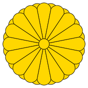
| Flag or logo since 1900-01-01* | Emblem or Symbol* |
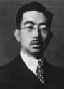 Emperor Hirohito (ruler of JAPAN since 1926-12-25) |
| Capitals & administrative places*: | Okinotorishima (Okinotorishima) |
|
| Official & national languages: | Japanese (ja) . |
|
Other Independent or Semi-Independent Polities within the 2024's internationally recognized Country boundaries: |
| JAPAN | Great Empire of JAPAN (Tokyo) |
Other Territories or Entities within the 2024's internationally recognized Country boundaries: |
| BONIN ISLANDS | BONIN ISLANDS Archipelago (Omura) |
| DAITO ISLANDS | DAITO ISLANDS Archipelago (Minamidaito + Kitadaito) |
| HACHIJO | HACHIJO Subprefecture (Hachijo) |
| HOKKAIDO | HOKKAIDO Agency (Sapporo) |
| MARCUS ISLAND | Southern Bird Island : MARCUS ISLAND (Minamitori) |
| MIYAKE | MIYAKE Subprefecture (Miyake) |
| OGASAWARA | OGASAWARA Subprefecture (Omura) |
| OKINAWA | OKINAWA Prefecture (Naha) |
| OSHIMA | OSHIMA Subprefecture (Oshima) |
| TOHOKU | TOHOKU Region (Sendai) |
| VOLCANO ISLANDS | VOLCANO ISLANDS Group (Iwo Jima) |
| |
|
|
ethnia.org © J.-M. Merklin |
|

|